All habitat guides

Habitat 04 / 05 · Freshwater ecosystems · Water and its margins

Rivers & wetlands

Freshwater habitat is more than open water. The channel, its shaded banks and the land that floods around it form a changing network.

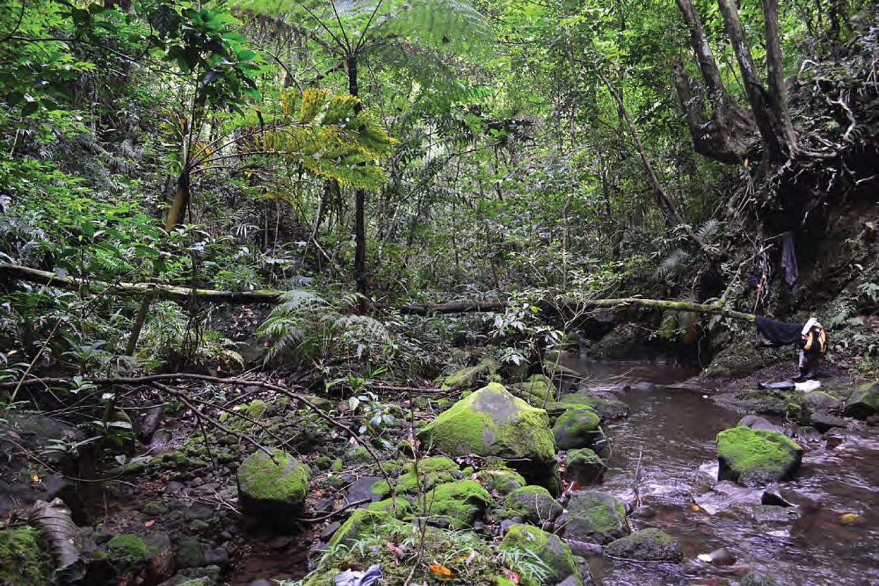
Shallow rocky stream beneath mature forest at Mount Cagua
A stream in mature forest on the crater floor of Mount Cagua, northern Luzon. Published as Figure 14 in Brown et al. (2013); photograph credited “JS”.Photo: JS, in Brown et al. (2013) · Original photograph · CC BY 3.0. Resized; full image retained.

Understanding the environment

A sense of the habitat.

A fast rocky stream, a still lake margin and a seasonally flooded marsh present different conditions. Flow, water depth, vegetation, sediment and the duration of flooding all help define the habitat. “Riparian” refers to the margins of rivers and streams; an animal recorded there is not necessarily living underwater.

Defining feature
Fresh water and the land it influences
Main contrast
Flowing channels, vegetated banks and still water
Key rhythm
Local rainfall, water levels and flood duration

Explore the structure · Water to land

From channel to floodplain

Select a zone to see what changes.

Flow & substrate

Channel

Moving water shapes the bed. Rocks, pools and sediment create different conditions along a single stream; a photograph of one pool cannot represent the entire river.

Notice current, depth, bed material and the presence of cover.

A conceptual river margin. Wetlands differ, and these zones can move or connect during floods.

Sources: Ramsar · Agusan Marsh site information sheet · Ramsar · Naujan Lake site information sheet · Brown et al. · Herpetofauna of northern Luzon (2013)

Field notes · 01

A wetland has a calendar

The Agusan Marsh site description distinguishes flowing water, lakes, herbaceous and scrub swamps, swamp forest and other flooded habitats. Seasonal water-level changes connect and separate these environments. There is no single dry-season calendar for every Philippine island: describe the local pattern and the date of an observation.

Sources: Ramsar · Agusan Marsh site information sheet

Field notes · 02

Different ways to live beside water

At Mount Cagua, Oxyrhabdium leporinum was recorded using forest streamsides and resting in fern axils. This illustrates a life at the water’s edge rather than a fully aquatic existence.

Freshwater also has more aquatic specialists. Lake Taal supports Hydrophis semperi, the Lake Taal sea snake, studied there together with Acrochordus granulatus. Its name is a reminder that common labels such as “sea snake” cannot substitute for species-specific habitat evidence.

Sources: Brown et al. · Herpetofauna of northern Luzon (2013) · Garcia et al. · Feeding ecology of snakes in Lake Taal (2014)

Field notes · 03

The catchment belongs in the picture

Water arriving from uphill carries the effects of land use. The Naujan site information describes a lake receiving both runoff and sediment from its surrounding watershed, and records pressures from land conversion and fishing. A meaningful habitat account therefore includes upstream cover, bank condition and surrounding farms or settlements, as well as the water itself.

Sources: Ramsar · Naujan Lake site information sheet

Pressures on Philippine habitats

What is at risk?

Freshwater habitats can be damaged far beyond their visible shores. Upstream land use and floodplain changes affect water quality, cover and the flooding cycle.

What helps this habitat

Protect bank vegetation and floodplain connections, reduce untreated waste and erosion, and manage withdrawals and fisheries with the whole catchment in view. Monitor water levels and habitat through different seasons.

Read further

Evidence & sources.

Guide checked 7 October 2026. Study dates and scope are retained below. Photographs illustrate habitats and do not establish snake occurrence at the photographed sites.

  1. Ramsar · Agusan Marsh site information sheet

    Official description of floodplain hydrology and wetland types; historical baseline, not a live water-level report.

  2. Ramsar · Naujan Lake site information sheet

    Official description of the lake, surrounding swamps, catchment and land-use pressures.

  3. Brown et al. · Herpetofauna of northern Luzon (2013)

    Field observations of Dendrelaphis, Cyclocorus and Oxyrhabdium; not habitat-preference experiments.

  4. Garcia et al. · Feeding ecology of snakes in Lake Taal (2014)

    Philippine freshwater observations of Hydrophis semperi and Acrochordus granulatus.

  5. DENR · Climate-responsive Agno River Basin master plan (2017)

    Basin-level diagnosis of wetland conversion, pollution, erosion and sedimentation.

Continue through the archipelago

Explore another habitat.

01

Rainforest canopy

Sunlit crowns, shaded branches and climbing vines form a vertical landscape. Explore how light, shelter and routes through the trees shape life above ground.

02

Forest floor

Leaf litter, roots, fallen wood and soil hold a mosaic of sheltered spaces. Discover the living ground layer and the secretive snakes that use it.

03

Montane forest

Mountain slopes reshape temperature, exposure and vegetation. Explore mossy trunks, cloud-influenced forest and the differences between isolated mountain habitats.

05

Mangrove to ocean

Tidal forests, shore refuges, reefs and open water are connected but distinct. Explore changing salinity and the different lives of sea kraits and fully aquatic sea snakes.